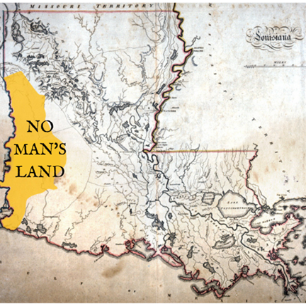
No Man’s Land (Sabine State or Neutral Strip)
No Man’s Land was ruled by highwayman and marauders had begun long ago when the French settled among the Caddo-Natchitoches Nation. Spain’s response to the French settlement was by positions
Los Adaes nearby among the Caddo-Adais.
France laid claim to the lands west to the Sabine River and Spain all lands east to the Red River, both were willing to abide by a makeshift border of two waterways, both called Arroyo Hondo. Today we know
the lower arroyo (stream) as the Calcasieu River, the upper is a creek near Natchitoches that is not at all a hondo (deep) but still retained the name. The Gulf of Mexico would serve as the southern boundary.
Los Adaes served as the capital of Tejas for 44 years, until France ceded Louisiana to Spain in 1762 in the secret Treaty of Fontainebleau at the end of the Seven Year’s War. Spain would retain the Louisiana
territory west of the Mississippi River and New Orleans. Once there was no threat from the French, Spain abandons Los Adeas and pulled back to the Sabine, leaving Spanish communities with no military presence.
The territory quickly turned violent.
The western boundary of the Louisiana territory was undefined at the time of the sale in 1803. President Jefferson believed the United State had purchased all the way to the Rio Grande, Spain disagreed. The
boundaries of Spanish and French territories had never been formally established prior to the Louisiana Purchase. Spain believed boundary was still the original boundary of Arroyo Hondo.
In 1806 Spain sent a very large force across the Sabine River. The United States responded by calling on militia and government troops both nations ready to defend what they thought was theirs. To avoid a conflict
between the two countries U.S. Army General James Wilkinson and Spanish Lieutenant Colonel Simón de Herrera respectively entered into an agreement declaring the disputed territory as Neutral Ground. They
agreed to keep Spain west of the Sabine River, while the Americans would respect the arbitrary boundary established by the French and Spanish decades before of the boundary of Arroyo Hondo. The Gulf of Mexico
would serve as the southern boundary and the thirty-second parallel of latitude would form the northern boundary. Within this boundary Spain had no rule in this region, but neither did the U.S. The area would be off
limits to soldiers of both countries. The agreement also included the stipulation of no new settlers from either country settling in the Neutral Ground area. Nevertheless, settlers from New Spain and the United States
territory began to move in. Some American settlers took Spanish land grants known as the Rio Hondo claims. Others simply squatted on unclaimed land.
No Man’s Land became a lawless area that would attract exiles, army deserters, political refugees, fortune hunters, squatters, runaway slaves and a variety of criminals. Eventually, the highwaymen organized to the
degree that they manned outposts and organized spies in order to better rob travelers and avoid the American and Spanish military. American revolutionaries, dead-set on taking Texas for the U.S., began showing up
in this area. Merchants in Natchitoches and present-day Texas, who relied on trading routes that went through No Man’s Land, began seeing their stock and supplies disappear.
Zebulon Pike Patrols 1808-1816
Patrolling Louisiana’s Neutral Strip became a delicate dance of political negotiation. Any action conducted by America aroused the suspicions of Spain. Any action by Spain made America leery. Understanding that the
solution required diplomatic finesse, Texas Governor Manuel Salcedo approached Louisiana Governor William C. C. Claiborne. Claiborne appointed Lieutenant Colonel Zebulon Pike to form a joint military expedition.
Pike had clear instructions. His soldiers were to remove only squatters and outlaws. Settlers who had lived in the region before the Louisiana Purchase were to be left alone. During his 1812 foray into No Man’s Land,
Pike’s troops drove out outlaws but also burned houses, tents, and camps belonging to many established settlers.
Ironically, the peaceful territory that Spain and the U.S. sought by creating No Man’s Land became everything but. It would take years of Spanish and American forces raiding the camps set up by these interlopers before
the No Man’s Land experiment, finally, was ended in 1821. The Adams-Onís Treaty, signed in 1819 and ratified in 1821, recognized the U.S. claim, setting the border at the Sabine River. Spain surrendered any claim to the
area. (Two years after the treaty was negotiated, New Spain won its independence as the Mexican Empire.) Even after the treaty, however, the Neutral Ground and the adjacent part of East Texas remained largely lawless.
The Regulator-Moderator War in East Texas in 1839-44 had its roots in the earlier anarchy of the Neutral Ground.
1809 – Adams-Onis Treaty draws lines
The Adams-Onis Treaty established the legal western boundary of the Louisiana Purchase and therefore the western boundary of the United States at the Sabine River. It was signed by John Quincy Adams and Luis de Onis
of Spain on February 22, 1819. The treaty was ratified by both governments and became effective on February 22. 1821. Creating eight parishes Allen, Beauregard, Desoto, Calcasieu, Natchitoches, Sabine and Vernon.
1821 – Pirate Jean Lafitte
Pirate Lafitte was run out of Galveston by U.S. Government, some of his men left by land settling in the Neutral Zone and East Texas adding to the already large number of individuals living there for whom strict adherence to
laws was not placed in high value.
1822 – Law and Order
Ft. Jesup was established to bring law and order to the former Neutral Strip, also to act as Indian agents, prevent slave insurrections, clear Sabine River of obstructions. It would take decades before the zone could be called safe.
In the 1850 “land pirates” such as John “Reverend Devil” Murrell who was the son of a Methodist minister, where he learned the Gospel well. He also learned how to steal and rob. Murrell was preaching around the Neutral Strip
in 1825, when he organized a large band of outlaws. As he would travel, he would establish hideouts and headquarters in various locations. One of his camps was at Midway Station near Ft. Jesup and Los Adaes. His most elaborate
headquarters was in a cave near Kisatchie forest, another set of caves in western Sabine Parish near the community of Clearwater. Murrell formed his outlaw band into seven clans and supposedly had his stolen treasure in eight
different banks. Clan members could be identified to each other with black locust tree bordered by two Spanish dagger plants in their front yards or a golden medallion around their necks.
John Murrell would travel around scouting out what type of livestock or valuables settlers might have. When he was preaching, he would send out his men to rob the home and farms of settlers. While waiting to preach in his open
air church, he would scout out the horses and mules the settlers either rode or drove as wagon teams to his service. After the services, these settlers would be robbed of their property. During this time there was not cash, just gold
or silver.
Murrell’s activities gave him the name the "Reverend Devil". Other than, his robbing and stealing, he also dealt in slaves. He once tried to accomplish an uprising by the slaves against their masters. He was never succeeded in doing so.
Many theories of what happen to John “Reverend Devil” Murrell, one Murrell was shot and killed by his own men near Hunt Hill, another he went to London, England with his treasure, where he died and was buried, another theory he
secretly left Louisiana and went back to either Mississippi or Arkansas where he live out his life, and the last theory was his gang mutinied and turned on him and hung him near Kisatchie Creek. John Murrell was so careful with locations
of his camps, he was so good at gaining the confidence of his men, and so very careful in his large scale robbery operation that he left few traces of his identity or of what happened to him.
With logging and timber harvesting in the Kisatchie Forest, the waybills carved into trees and rocks have disappeared over time. Around 1942 the US Forest Service decided to dynamite the caves near Kisatchie to keep people from getting
lost, injured or even killed as they were hunting for “Murrell’s Treasure”.