

St. Tammany Parish
LAGenWeb

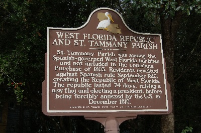 1810 West
Florida Republic
1810 West
Florida RepublicSt. Tammany Parish was among the Spanish-governed West Florida parishes and not included in the Louisiana Purchase of 1803. Residents revolted against Spanish rule September 1810, creating the Republic of West Florida. The republic lasted 74 days, raising a new flag and electing a president, before being forcibly annexed by the U. S. in December 1810.
This parish is situated in the southeastern part of the State and
contains 590,720 acres of land. The formation is pine hills, pine flats,
alluvial land and wooded swamp; soil fertile and productive. It is
drained by Pearl river, West Pearl, Chefunctee (or Tchefuncta) river and
Bogue Chitto, Bogue Phalia and other streams. The New Orleans and
Northeastern railroad, belonging to the Queen and Crescent System,
passes through the parish. Covington, situated on the Bogue Phalia, is
the parish site. It is connected with the New Orleans and Northeastern
railroad at West Pearl Station. Sugar, rice, cotton, corn, hay, oats,
beans, sweet and Irish potatoes and truck and grarden varieties are
extensively raised. The fruits are peaches, plums, pears, apples, figs,
prunes, grapes, pomegranates, quinces and persimmons. Cattle, hogs,
sheep and a few horses are raised. Game consists of squirrels, rabbits,
coons, opossums, der, wild turkeys, wild ducks, papabots, becasin,
snipe, partridges and rice-birds. Fish are plentiful in the streams and
lakes, fine trout, bass and pike are taken. The timber is pine, oak,
cypress, gum, elm and hickory. There are 18,250 acres of United States
Government land and a quantity of State public lands in the parish.
Private land is worth from $2.00 to $20.00 per acre.
Transcribed
02 Sep 2019 by Norma Hass from An invitation to immigrants. Louisiana:
Its Products, Soil and Climate, published in 1894, pages 171-172.
Penn, Alexander, G., planter and member of Congress, was a Virginian by birth. He received but a limited education; moved from Virginia to St. Tammany parish, La., in 1812, where he became a planter; served in the Louisiana state assembly; was postmaster of New Orleans from 1845 to 1849, when he was elected to the 31st Congress as a Democrat, to take the place of J. H. Harmanson, deceased, and was reelcted to the 32nd Congress. He died at Washington, D. C., May 8, 1866. [volume 2, page 299]
Rouquette, Adrien, author, was born in New Orleans, La., Feb. 13, 1813. He was educated at the College de Nantes, France, and then spent ten years in traveling over Europe. Returning to America and to his Louisiana home, he became interested in the Choctaw Indians in St. Tammany parish, settled among them and taught many of them to read and write. The Indians called him "Chata Ima." In 1845 he received the priestly orders of the Catholic church, but continued among his Choctaw friends until 1886, when his health failed and he went to New Orleans. There he was tenderly cared for by the sisters of charity until his death, which occurred at the Hotel Dieu on July 15, 1887. Father Rouquette, was the author of several prose and poetical works. [volume 2, page 396]
St. Tammany Parish, established in 1811, is one of the "Florida parishes." It
is named after "St. Tammany," the Delaware chief, who before and during the
Revolutionary war was chosen for his reputed virtues as the patron saint of the
new republic. The Louisiana parish was so named because it had a large Indian
population at the time of its establishment. It is situated in the extreme
southeastern corner of the state and from its original territory have been
carved Washington parish and a part of Tangipahoa. It is now bounded on the
north by Washington parish; on the east by the Pearl river, which separates it
from Mississippi; on the south bounded by Lake Borgne, Orleans parish and Lake
Pontchartrain; and on the west by Tangipahoa parish. It was not until the middle
of the 18th century that any whites settled west of the Pearl river. After the
Revolution some families emigrated from Georgia, the Carolinas and Virginia and
settled in this unbroken wilderness. Some of the earliest to take up claims
under the Spanish were John Castonquat, in 1795; John Spell, in 1798; Joseph
Slatten a year later; the Coopers in 1800 and 1801; William Wilson in 1802;
William W. Collins, in 1803; Matthew Robertson and Joseph Cutterer in 1804, and
a number of others who came in 1806. During 1808 new claims were located by the
Galloways, Jesse Barker, Lawrence Stecker, Charles Roberts, Gideon Yarsborough
and a few others. David Glover, John Mitchell, John Brinkley, the McC!endon
family, the Leas and John Tallev established themselves in 1810. The first
courthouse was erected at a place called Claiborne, on the west side of Bogue
Falia, about opposite to the present town of Covington, but the parish seat was
removed to Covington in 1829. In 1819 the northern part of St. Tammany was taken
to form Washington parish, and in 1869 a large part of its remaining territory
was taken to form Tangipahoa parish. After the division, the population left to
St. Tammany was larger than the whole in 1860, which shows how rapidly settlers
established themselves in this region after the close of the Civil war.
Large brickyards were maintained and lumbering was a very important industry up
to the Civil war, but with the end of slavery these industries nearly ceased and
many years elapsed before they were revived. The main water courses of the
parish are the Pearl river on the east, the Tehefunete river on the northwest,
the Bogue Chitto in the northeast and the Bogue Falia through the central
portion and their many tributary streams, all of which are used in the extensive
lumber industry, About 1856 it was discovered that the springs around Covington
possessed medicinal properties and since then it has been the resort of
invalids. The most famous spring is the Abita, a few miles northeast of
Covington, with a capacity of 40,000 gallons a day, and the water is bottled and
exported. Large hotels have been built and this district is a resort the year
round for both northern and southern people. St. Tammany has a level and
undulating surface of 871 square miles, formed of coast marsh, pine flats, pine
hills, alluvial land and wooded swamp. The parish lies in the southern part of
the long leaf pine region and almost its entire area is heavily timbered. The
principal growth is pine, though oak, beech, gum, dogwood and holly are found in
the river and creek bottoms. Along the shores of Lake Pontchartrain are large
tracts of live oaks that grow to great size and for many years were practically
uncut. The soil of the bottom lands is of alluvial deposit that produces as fine
cotton, cane and sorghum as any in the state, while the pine lands have a
surface soil of sandy loam, which with reasonable fertilization will produce
good crops. The proximity of St. Tammany to the New Orleans market, and the
cheap and excellent transportation facilities make almost any industry of the
parish profitable. Sugar, rice and cotton are the largest crops, but corn, hay,
oats, beans, potatoes, all kinds of garden vegetables, and fruits and berries do
well and are raised in large quantities, and now that the parish is well
provided with railroad transportation, truck farming and fruit growing will
doubtless increase. Stock raising and dairying have increased as the timber is
cut and are paying industries to the farmer. Sawmills are numerous, cutting
millions of feet of the finest lumber in the world each year. Most of the
railroads in the parish have been built within the last few years and materially
increased its' prosperity. The New Orleans & Northeastern R. R. runs across the
southeastern part, the New Orleans Great Northern R. R. traverses the entire
eastern portion north and south, with branches to nearly all sections of the
parish. Cheap shipping: by steamboat is afforded on Lakes Borgne and
Pontchartrain. The principal towns are Covington, the parish seat, Abita
Springs, Alton, Bayou Lacomb, Chinchuba, Folsom, Madisonville, Mandeville, Pearl
river, Slidell and Sun. The following statistics with regard to the parish are
taken from the U. S. census for 1900: number of farms 397, acreage, 87,667;
acres improved, 19,491; value of land and improvements exclusive of buildings,
$226,290; value of farm buildings, $116,730; value of live stock, §171,382;
value of all products not fed to live stock, $186,428; number of manufactories,
29; capital invested, $669,973; wages paid, $236,467; cost of materials used,
$337,673; total value of all products, $756,946. The population of the parish in
1900 was 8,415 whites, 4,889 colored, a total of 13,304, an increase of 3,175
over the year 1890. The estimated population for the year 1908 was over 15,000.
[volume 2, pages 422-424]
Extracted 02 Sep 2019 by Norma Hass from Louisiana; comprising sketches of counties, towns, events, institutions, and persons, edited by Alcee Fortier, published in 1909.
Copyright © 1996- The USGenWeb® Project, LAGenWeb, St. Tammany Parish

This page was last updated
06/13/2025