

In a rural part of northeast Louisiana, approximately 25 miles
from Lake Providence (near the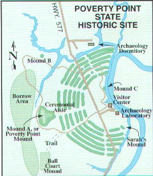 small town of Epps) stands the largest and most important earthworks
in the Western Hemisphere. The Poverty Point mounds were built in
1500 B.C., which pre-dates the Parthenon in Greece, the Great Wall
of China, and the Colosseum in Rome. The earthworks are situated on
Bayou Macon (pronounced 'mason'), which separates East and West
Carroll Parishes.
small town of Epps) stands the largest and most important earthworks
in the Western Hemisphere. The Poverty Point mounds were built in
1500 B.C., which pre-dates the Parthenon in Greece, the Great Wall
of China, and the Colosseum in Rome. The earthworks are situated on
Bayou Macon (pronounced 'mason'), which separates East and West
Carroll Parishes.
The Native Americans used the Bayou as a
means of transportation. They were also able to ship in supplies and
sell their goods to other parts of the territory. The inhabitants of
Poverty Point used the natural resources that were plentiful in the
Mississippi floodplain. Their culture is considered a
pre-agricultural society, but the amount of man power and the
thousands of hours of work that it took to construct the earthworks
suggests a highly evolved society, living and surviving together.
The earthworks were built by the Poverty Point people, digging and
carrying thousands of loads of dirt by hand in woven baskets.
Poverty Point's "central
construction consists of six rows of concentric ridges, which at one
time were five feet high. The five aisles and six sections of ridges
form a partial octagon. (Two of the aisles correspond with the
summer and winter solstice sunsets.) The diameter of the outermost
ridges measures three-quarters of a mile. It is thought that these
ridges served as foundations for dwellings although little evidence
of structures has been found. However, features and midden deposits
uncovered during excavations support this theory. Earthen mounds
were also built on the site. Immediately to the west of the
concentric ridges lies Poverty Point Mound, a spectacular bird
shaped mound measuring about 700 by 640 feet at its base and rising
70 feet. To the north is Mound "B," a 20 feet high conical mound,
which was constructed over a bed of ash and burnt bone fragments."
--Quoted directly from the Poverty Point State Historic Site
brochure from the Office of State Parks
During excavations,
hundreds of personal articles were recovered. Bird effigies, stone
tools, spears, and gems that are not native to Louisiana have been
found, along with hundreds of round, clay balls. Historians believe
that these clay balls were used for cooking. The balls were heated
in a fire and then placed in a pit, which created an oven for
cooking meat and other foods.
Today, Poverty Point is a
popular tourist attraction and a site for archeological study. It is
located southwest of Lake Providence on LA 577 off of LA 134. The
site consists of a 2.6 mile walking trail or tram ride, which allows
visitors to make their way up the large earthen mounds. Artifacts
are displayed in an informative museum, which features an
audio-visual history of the site and an observation tower gives
visitors a birds-eye view of the mounds. Picnic areas and restrooms
are also maintained. A nominal fee is charged for entrance into the
museum.
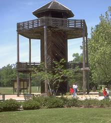
Observation Tower at Poverty Point
Poverty Point State Historic Site
Coordinator:
Vacant
State Coordinator:
Marsha Holley
If you have questions or problems with this site, email Marsha Holley, State Coordinator.