

Below are the links to the cemeteries in Natchitoches Parish, as well as some additional information about those cemeteries. If you do not see the cemetery linked to a page, I do not have any additional information. Please note: Most of the Parish cemeteries are only partially transcribed. If you do not see your ancestors listed on the pages, you can submit the information for addition to that cemetery.
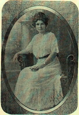
Violette Wiggins Newton relates her search for ancestors in poetry form. Submitted by Robert Sheldon Liles, g-g-g-grandson of Dewittie Jane Ellzey Wiggins.
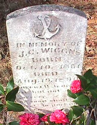
FINDING UNCLE ALONE
In grief she bought two places--one
for her--and on his stone, beneath his name and dates, inscribed
these words Together here we'll lie
unto eternity, when we shall
meet again.
We drove a narrow road for miles through piney woods, stopped at the graveyard's iron fence and went inside to walk among the blackened stones and stand before his own.
Our thoughts were longer than the shadows cast by pines and loner than his one small stone proclaiming its small lie.
For grief wears thin and dissipates when blood calls once again to blood. She married soon, and married once again, to go from love to love and grief to grief.
We never learned her final place or even tried to guess what words are writ below her name...or what expression on her face when he was waiting for her at the holy gates.
FINDING UNCLE'S FAMILY
When Joseph fell in the moving saw
and died, the little ones he'd brought to his second marriage
stood beside
the new wife and cried. And that was all we knew
of him,
and them, and her, who'd had
his stone set with his
name.
Where had they gone?
We searched the records and
the winding roads, asked until at last, we drove red dirt
through pines, and there, deep in the greenwood, found
their
polished stones. She lay
beside new husband and their own and
some of Joseph's children too.
We looked and had our long,
long thoughts. And thought that this good woman mothered five,
not quite her own, and made a life for them. And met, in years
to come, no doubt, their father
with her head held high
when that time came.
CEMETERY NAME: LOCATION
A. R. Dowden: On Kisatchie National Forest land - located about five miles northwest of Kisatchie, LA (intersection Hwy 117 and 118),near the site of the first Kisatchie Post Office, off Forest Service Roads 350 and 377.
Abandoned Cemetery: Southwest Natchitoches Parish, Louisiana. (Surnames are Bishop, Greer,Hawkins)
Airhart: On Kisatchie National Forest land
Allen Baptist African-American Cemetery: Located a half mile west of the village of Allen in northwest Natchitoches Parish.
Allen Methodist African-American Cemetery: Located 3/4 mile west of the village of Allen in Northwest Natchitoches Parish
American Cemetery: 321 2nd St.; Natchitoches, LA 71457, Site of Old Fort St. Jean Baptiste
Antioch Cemetery (African-American): Bellwood, La. Located about a mile and a half on 478 from 117, sign on the left. The cemetery is about 3 miles down that road.
Antioch Cemetery: Goldonna, La.
Bay Spring Cemetery: Located near the Gorum Community. Take Interstate 49 from Alexandria, exit at Chopin in Natchitoches Parish. Turn left on Highway 490 for 1.3 miles and go left on Bay Springs Road for 1.0 miles.
Bayou Blue: Provencal----located off LA Hwy 120, about 4 miles east of Provencal, LA. If approaching from Provencal (traveling east), turn left onto Parish Road 618 ( Bayou Blue Road), travel mile, turn right, travel about one block and the road ends at the Bayou Blue Cemetery.
Beasley Cemetery
1998: Bayou Livrogne----Turn off State Hiway 117 onto Long Leaf Trail. Approximately 10 miles up Long Leaf there is a marker for the Beasley Cemetery Road. The cemetery is about 3 miles up the road and you will probably need a 4 wheel drive to get to it.
Beasley Cemetery 1999, With Pictures: Located near Lotus, LA, about 15 miles south of Provencal, LA, in the Lotus-Red Dirt area of the Kisatchie National Forest. Turn east off Hwy 117 at the Forest Service Work Center; travel about 5 miles, and the there is a sign on the right indicating the cemetery, which is about three miles along this road.
Bellwood Cemetery: Bellwood. Located about 100 yards or so west of LA. Hwy 117 next to Bellwood Baptist Church.
Bellwood (OLD) Cemetery: Kisatchie--This cemetery is located on the grounds of the old Bellwood Academy. The community of Bellwood began at this location and continued about four miles south of the present day location on Highway 117, just north of Kisatchie.
Bellwood (OLD) Cemetery (New Listing): Kisatchie-Located adjacent to the Kisatchie National Forestry Work and Visitors Center complex about three (3) miles south of Bellwood, La.
Bethany Cemetery: Located about four miles north of Marthaville, LA on Parish Road 1221 in the Bethany Community. The Cemetery is situated between the Jennings Chapel Church and the Bethany Church.
Beulah Methodist Church Cemetery: Marthaville----located behind the Beulah Methodist Church, just outside of Marthaville
Billy Dowden/Dowden Cemetery: KisatchiE----located about four miles west of Kisatchie, LA off Hwy 118.
Black Lake Full Gospel Church Cemetery: Campti, La.
Black Lake Cemetery: Campti, La.
Bludworth Cemetery: Located some five miles west of the Kisatchie Forestry Work Center, which is about twenty miles south of the LA Hwy 6 and LA Hwy 117 junction at Hagewood, LA, eight miles west of Natchitoches, LA.
Bolton Cemetery: Located inside Kisatchie National Forest (Natchitoches Parish). A large lone oak tree shades the graves, and the cemetery is visible from LA Highway 119 near Long Leaf Vista.
Booty Cemetery: Kisatchie----Located on Hwy 118, a little over a mile west of the intersection of Hwy 118 and 117.
Botton Cemetery: Gorum, La.
Breda/Hertzog Cemetery: This cemetery is located at the intersection of Roy Drive and Bonnette Street in the northwest section of the city of Natchitoches.
Breda Town Cemetery: African American/non-denom.
Breedlove Cemetery: Located near the Oak Grove Community about five miles west of Natchitoches, LA.
Brister Cemetery: From Provencal take Highway #117 towards Leesville for 1 mile. Turn left on Harmony Church Road and go 3 miles.
Calvary Baptist Church Cemetery: Located off of Hwy 3191 in Natchitoches Parish, La. The church and cemetery are just above the split in the road that goes by the TGT plant and old Hwy l.
Calvert Cemetery: Lena, La.
Camel Cemetery: Natchitoches, La.
Campti Baptist Cemetery/L.C. Weaver Memorial Cemetery: Campti, La.
Campti Cemetery: Campti, La.
Campti Catholic Cemetery: Campti---on La 480 - Rear of the Church of the Nativity of the Blessed Virgin Mary
Catholic Cemetery: Gorum ---Catholic Cemetery
Catholic Cemetery: Marco, La; non-denom.
Catholic Cemetery: 5th St. Natchitoches Catholic Cem.
MORE
Cedar Cemetery: Vowells Mill----
Cedron (NEW) Cemetery: Vowells Mill
Cedron (OLD) Cemetery: Located on Bayou De Muse Creek, on the Vowell's Mill/Provencal Road, in the southwestern corner of Natchitoches Parish.
Central Cemetery: Robeline, LA
Choctaw Island Baptist Church and Cemetery: From the Grand Ecore Bridge travel 2.6 Miles on Hwy 6 toward Clarence and turn right onto La 1225 South and go 1.6 miles and the Choctaw Island Baptist Church and Cemetery will be on your left side on the edge of the road.
Clark Cemetery: Clarence, La.---At Clarence take 1225 and get to where 1226 meets. Turn right on dirt road, and follow around curve to left. The road ends there at the Cemetery.
Clear Lake Cemetery: Take Hwy. 1226 from Clarence to Clear Lake Cemetery Rd. There is a sign that says St. Peter's Catholic Church at the highway.
Cloutierville Catholic Cemetery /
St. John the Baptist Catholic Cemetry: Cloutierville
Cloutierville Baptist Cemetery: Cloutierville----The cemetery and church are located in Cloutierville on Highway 1 on the right side of the road.
Coldwater Cemetery: The Coldwater Cemetery is located to the rear of the Coldwater Baptist Church, in Hagewood, LA (Hiway 6, eight miles west of Natchitoches.)
Cotton (Cotton-Cordova) Cemetery: The Cotton Cemetery, sometimes referred to as the Cotton-Cordova Cemetery, is located in the Spanish Lake / Allen / Ajax area of Natchitoches Parish ( Hwy 485).
Coulee Bethel Cemetery: Campti
Curby Cemetery: Located in the Kisatchie National Forest lands, west of the Forestry Work Center at Bellwood, LA, it consists of a single grave.
Davis Springs Cemetery: Located approximately 6.5 miles north of Campti, LA; .2 miles east of Highway 71.
De Blieux Cemetery: Natchitoches, La.
Demery Cemetery: Located two miles northeast of Natchitoches off Hwy 6 East; on Holden Road, about 1/2 mile, on the right.
DeRussey/Russell Cemetery: Grand Ecore area: Traveling east on LA Hwy 6 from Natchitoches, turn left onto Parish Road 429 just before reaching the Red River-Grand Ecore Bridge (Tauzin Island Road). The cemetery is located a quarter mile west, on the left. Walk up the highline right-of-way to the top of the hill and the cemetery is located in the wooded area to the right.
Dowden/(Billy Dowden) Cemetery: Located about four miles west of Kisatchie, LA off Hwy 118.
Dowden-McLaren Cemetery: Located in Natchitoches Parish, in Kisatchie National Forest. Take Highway 119 to Long Leaf Vista Road, several miles. Turn right on Parish Road 311, right on Parish Road 342, left on Parish Road 347.
Dowen Cemetery: Flora, La.
Emanuel Cemetery: Take I-49 North from Alexandria, and exit at Chopin (exit 113). Go .2 miles on LA Hwy. 490, and turn left (West) onto Parish Road 820 (Emanuel Road). Continue on this road for approximately 3.2 miles to Emmanuel Catholic Church (Chopin community). The cemetery is located on a hill, less than .2 miles behind the church.
Evergreen Cemetery: Goldonna
Evergreen Baptist Church Cemetery: St. Maurice - African American Cemetery
Fairview Alpha Baptist Cemetery: Fairview View Alpha, LA.
Fern Park Cemetery: Texas Street, Natchitoches, LA
Flatwoods Cemetery: Flatwoods, La.
Fleming Cemetery: Marthaville, Natchitoches Parish, LA
Folly/Polly Mack Cemetery: Kisatchie-----Off Hwy 118...at least 2 miles down Hwy 118 from intersection with Hwy 117 - on right side of highway (sign). Take road off highway about 1-1/12 miles into woods-fenced in.
Ford Graves: On Kisatchie National Forest land
Foshee Cemetery: Bellwood, La.
Fox Cemetery: Vowells Mill, Natchitoches Parish, LA. Location: West and south of Vowels Mill, south of LA Hwy 478; on private property.
Friendship Cemetery: Provencal, Natchitoches Parish, LA Location: LA Hwy 117 south of Provencal about three miles, turn east on Parish Road 725, approximately one mile to Friendship Cemetery marker, turn right and about 1/4 mile to cemetery.
Galbrath Cemetery: From March, travel on Highway 1 for about 1 mile, turn right and go about 2 miles. There are about 45 graves with iron crosses, about 15 marked with stones and 5 brick vaults.
Gallien Cemetery: Clarence; non-denom.
Gilcrease Cemetery: Approximately 4 miles south of I49 and La.6 intersection, 1/4 mile west.
Goldonna Cemetery: Goldonna----located on "The Loop" in Goldonna. Goldonna is located between Calvin and Creston, La.
Good Hope Church Cemetery: On Kisatchie National Forest land
Gorum Cemetery: From LA Hwy. 119 out of Flatwoods, go North toward the small settlement of Gorum. At the Natchitoches Parish line, go 6.0 miles to Gorum. Cross over the Bayou Pierre Bridge and immediately turn left (West) onto Gorum Cemetery Road. Continue on this gravel road, bearing to the right at the "Y" for approximately .7 miles. Cemetery is on top of a hill on the left (south) side of the road.
Grand Ecore Cemetery: Grand Ecore; African American/Baptist
Green Grove Cemetery
African-American: Located one mile East of Readhimer on Hwy 126, then North on Green Grove Church road about 1/4 mile.
Greenville Cemetery: Clarence, African American/Baptist
Hardamon Cemetery: Bellwood, La. /p>
Harmony Cemetery: Location: Approximately one mile south of Provencal, turn east on Harmony Road; the church and cemetery are about three miles down this road, on the left.
Hathorn Cemetery: Ashland, La.
Hawkins: On Kisatchie National Forest land
Hawkins: Chestnut
Hawthorne Cemetery: Location: Provencal, LA, south on LA Hwy 117 one mile, left onto Harmony Road, about one half mile and is on the right; private property and inaccessible by car.
Hickory Grove Cemetery: Robeline---Adjacent and to the rear of Hickory Grove Congregational Methodist Church along the south side of LA Hwy 6 on the east side of Robeline.
Hickory Grove/ Murray Cemetery: Vowells Mill - Located south of Craig Loop in Vowels Mill, the cemetery under fence appears to be both the old Murray (sometimes referred to as the Becky Murray) cemetery and a newer cemetery, both now named the Hickory Grove Cemetery.
Howe Cemetery: Located vicinity Fairview Alpha and Coushatta, Natchitoches Parish
Iron Springs Cemetery
African-American: Take Coushatta-Ashland Hwy, Iron Springs Rd is a dirt road about 3 miles from Ashland. Cemetery is located on the corner of Swiney Hood Rd. and Iron Springs Rd.
Jackson Cemetery: South of Provencal,LA, Hwy 117, about 7 miles to intersection of 20 LA117 and Hwy 478; turn east on 478, approximatedly 2 miles to Parish Road 724; Jackson Cemetery sign; approximately 1/2 mile to Jackson Cemetery at end of road.
Jackson Square Cemetery: Amulet and Howell Streets
Jewish Cemetery: Located on Martin Luther King Drive (formerly Lee Street) in the city of Natchitoches.
Jones-Pullen-Thompson Cemetery: The Cemetery is located about five miles south of the I-49 and LA Hwy 6 intersection, approximately one miles south of the 132 exit. The cemetery is located on private property in the vicinity of the Old River Hill Cemetery.
Key Cemetery: Located on the Kisatchi Falls Road off Hwy 118. Traveling toward Kisatchi, turn left on th road. Union Cemetery is about 3 to 4 miles on the left. Continue past Union Cem. to the dead end and turn right.
Kile Cemetery (aka Union Cemetery): Kisatchie-Located on Kisatchie Falls road off Hwy 118. Travel 118 toward Kisatchie. Turn left on the Falls road. The cemetery is about 3.5 to 4 miles on the left.
Killingsworth Cemetery: From Natchitoches take Highway 84 through Clarence to the caution light and turn left onto Highway 1226. The road runs along Bayou Borbeaux, pronounced "Boobie". The cemetery is about two miles west of Goldonna.
Lambertown Cemetery: Located about three miles north of Robeline, LA, on LA Hwy 120; turn east at the Shamrock Emmanuel Gospel Church and continue east for one-half mile. The Advent Christian Church and the adjacent Lambertown Cemetery are located on the right.
Lawrence Serenity Sanctum Cemetery: Located on Welch Street, north of Texas Street in Natchitoches. (African- American) (Office-910 3rd Street, Natchitoches, LA 71457)
Lee Cemetery: Natchitoches
Little Moss Cemetery: Located 1 mile east of the intersection of La Hwy 117 and Parish Road 835, at Bellwood, La.
Logan Chapel Cemetery: King Hill - Natchitoches
Manasco Cemetery: Vowells Mill-From Provencal, LA travel south on LA 117 about 5 miles to the intersection of Hwy 478; turn right, travel 7 miles to intersection of Vowels Mill/Provencal Road (PR 651), Tom Lee Road (PR 745), and Red Rock Road (PR 750). Turn left on Tom Lee Road (PR 745) and travel 1.8 miles. The cemetery is sign is on the right.
Marco Cemetery: Aloha
Marshall Cemetery: Provencal
Marthaville Cemetery: Marthaville; Located one-quarter mile north of Marthaville, Natchitoches Parish, LA, on the right side of Hwy 120.
Marthaville African-American Cemetery: Marthaville; located one-half mile north of Marthaville, Natchitoches Parish, LA, on Hwy 120.
Martin Cemetery: Located approximately one mile south of Hagewood, LA on LA 117, left onto Natchitoches Parish Road 632 (John Whatley Road), one and one-fourth miles east to end of road at Pine Grove Church and Cemetery. The Martin Cemetery is slightly north of the Pine Grove Cemetery, located on private property, no road. None of the graves are in the Martin Cemetery are marked.
Martin/Weldon Cemetery: Located on Forest Service road #304, which is approximately two miles south of Bellwood, LA.Continue on Forest Service road # 304 for about three miles west of LA 117 and the cemetery sign is on the right.
Massey-Moss: No Listing.
McCartney Cemetery: Hollis Creek
McGaskey Cemetery: Vowells Mill; African American
McCaskill Cemetery: Located 4 miles North of Marthaville
Memory Lawn Cemetery: Grand Ecore Rd. Hwy 6 East; Natchitoches
Merrell Cemetery: Located inside Natchitoches Parish, off LA Hwy 1. Take I-49 North of Alexandria and exit at Lena sign. Go a short distance to LA Hwy. 1, turn left .5 miles past Rapides Parish Line, north of the community of Lena.
Middle Creek Cemetery: Located adjacent to Middle Creek Church, on Barron Road, midway between Bellwood (Hwy 117) and Peason (Hwy 118).
Montgomery Cemetery: Kisatchie
Mora Cemetery: Located on the grounds of the Mora Baptist Church, Mora Community (Natchitoches Parish), about two miles from the Rapides Parish line.
Morningstar Cemetery: African American/Baptist
Moss Cemetery: Bellwood-On the Kisatchie National Forest land
Mount Carmel Cemetery (2): Robeline, La.
Mount Olive Cemetery
(African-American): This cemetery is located on Five Forks Rd, Creston, La. Take the Ashland Highway from Creston or Ashland to the Five Forks Rd, turn on first gravel road to the right. There's a sign but part of it is broken off.
Mount Pilgrim Baptist Cemetery: Clarence, LA; African American: from Natchitoches: Hwy 6 east to Clarence, Hwy 84 east 3.5 miles, right onto Parish Road 1226, church and cemetery on the right. Directions courtesy of Pamela D. Spigner.
Munson-Villerman Cemetery: North of Robeline-Located in a wooded area about one mile west of the Rocky Mount Church and Cemetery, which is located near the Sabine and Natchitoches Parish line.
Murphy Cemetery: East on Woodyard Drive (locally known as Fish Hatchery Road); follow river for about five (5) miles. Cemetery will be on the right. Fenced, gate locked.
Murray/Hickory Grove Cemetery: Vowells Mill - Located south of Craig Loop in Vowels Mill, the cemetery under fence appears to be both the old Murray (sometimes referred to as the Becky Murray) cemetery and a newer cemetery, both now named the Hickory Grove Cemetery.
Nash Cemetery: Further down the road from the Friendship cemetery
Nativity Cemetery: Fairview Alpha
New Cedron Cemetery: Vowells Mill; located about 7 miles west of the intersection of Hwy 117 and 478; the intersection is about 5-7 miles south of Provencal or about 15 miles north of Kisatchie. The interesection of 117 and 478 is between Provencal and Bellwood; wide and well marked. Proceed west about 7-8 miles on 478 and the New Cedron Church /Cemetery sign is on the left. Travel down that road about a mile and the church and cemetery are on the left, about two blocks; can be seen from this road.
New Kisatchie Cemetery: Kisatchie---Located on Hwy 118 approximately 0.2 of a mile from intersection of Hwys 118 and 117 on the right side of the highway.
New Mt. Zion Cemetery
African-American: Located on Goldonna Hwy., Creston
New Town Community Cemetery: New Town; African American
Niette Cemetery: Location: Natchitoches Parish, LA, on private property of Leroy Miller, Parish Road 485, about one mile south of the Saint Anne Roman Catholic Church, which is situated some five (5) miles north of Robeline, LA in the Spanish Lake area.
Oak Grove Cemetery (formerly Stewart Cemetery): Chestnut - Oak Grove Cemetery (Stewart Cemetery) is on the Morgan Quick Rd. near Chestnut, La. It is located off Hwy 9 or off the Ashland Hwy.
Oak Grove Cemetery: Oak Grove; Methodist----Take Hwy 540 (old Hwy 1) from Natchitoches and turn on Hwy 1504 (Oak Grove Road). Go past TN Gas then turn right onto Eight Mile Loop. The Church and Cemetery are about mile on the right side of the road.
Old Bellwood Cemetery (New Listing): Kisatchie-Located adjacent to the Kisatchie National Forestry Work and Visitors Center complex about three (3) miles south of Bellwood, LA.
Old Bellwood Cemetery: Kisatchie--This cemetery is located on the grounds of the old Bellwood Academy. The community of Bellwood began at this location and continued about four miles south of the present day location on Highway 117, just north of Kisatchie.
Old Bethel Cemetery: Located nine miles west of Natchitoches, LA on LA Hwy 6 (one miles west of Hagewood, LA), turn right onto Shady Grove Road (Parish Road 556 ), then approximately two miles, turn right on Old Bethel Church Road (Natchitoches Parish Road 553), travel about one and a half miles then turn left at Old Bethel Church and Cemetery sign.
Old Cedron Cemetery: Located on Bayou De Muse Creek, on the Vowell's Mill/Provencal Road, in the southwestern corner of Natchitoches Parish.
Old Kisatchie Cemetery: Kisatchie, La.
Old Mt. Zion Cemetery: No location information.
Old Pisgah Cemetery: Marthaville
Old River Hill Cemetery/Scroggins Cemetery: Location: Five miles south of I-49 and LA Hwy 6 intersection, take Exit 132, turn east onto LA Hwy 478, then south immediately after clearing the overpass (2/10 mile); continue about one quarter mile, then turn right onto LaCaze Road (gravel road). Continue on this road for about 2 miles, and cemetery is on the left side of road. The road dead-ends at Old River a few hundred yards on.
Owen-Bolton Cemetery: On Kisatchie National Forest land
Pace Cemetery: From Natchitoches take Highway 84 through Clarence to the caution light and turn left onto Highway 1226. The road runs along Bayou Borbeaux, pronounced "Boobie" and the cemetery is on the left side of the road.
Page Cemetery: Between Robeline and Natchitoches, 5 miles east of Robeline, Louisiana on the north side of Parish Road 556.
Pardee Cemetery: At Black Lake, Campti.
Parish Family Cemetery: Located on Robert Parish's old homestead, about two or three miles north-northeast of Robeline. Take the state highway north of Robeline towards Marthaville for about two miles. Turn right onto a road near a church. A sign at the interesection near the cemetery states the direction to Anthony Baptist Church. (This is not a church cemetery, as the sign just happens to be near the cemetery.) The cemetery is located at the end of this road; about one mile. (Directions: Randy DeCuir)
Pine Grove Cemetery: The Pine Grove Cemetery is south of Hagewood, about one (1) mile; turn east on Parish Road 632 (John Whatley Road). The Pine Grove first marked burial was in 1872.
Pine Grove Cemetery
(Southern Natchitoches Parish): Pine Grove Cemetery is located .5 miles south of LA Hwy. 118 in Southern Natchitoches Parish about 1.0 miles North of the Vernon Parish line. Look for the sign off Hwy. 118 about 12.0 miles east of Kisatchie LA. From opposite direction, take LA Hwy. 8 West, turn right on Mora Road and continue about 3.0 miles past the Mora Baptist Church road sign. There is a small sign on the left at a small rise.
Pisgah Cemetery: Marthaville
Pleasant Hill Cemetery: Near Chestnut - Take Hwy. 9 from Campti between Creston and Chestnut. Turn right on Pleasant Hill Church Rd., 1 mile.
Polly Mack/Folly Cemetery: Kisatchie----Off Hwy 118...at least 2 miles down Hwy 118 from intersection with Hwy 117 - on right side of highway (sign). Take road off highway about 1-1/12 miles into woods-fenced in.
Provencal Cemetery: Provencal - Location: From LA Hwy 117, turn east at the intersection onto LA Hwy 120, then immediately turn left (north), go one block then turn right (east), continue about four blocks, bearing left at the Y intersection; about two blocks to the cemetery. The older section of the cemetery is located on the right side of the street, the newer section on the left.
Rachal Cemetery: Take I-49 North from Alexandria, get off at Exit # 107 (Lena/Flatwoods) and turn right. At stop sign on old LA Hwy. 1, turn right briefly and then back left. Continue to new LA Hwy. 1 (about .5 miles total) and turn left. Go approximately .5 miles past the Natchitoches Parish sign, and turn right on the next road toward Lock and Dam (no sign). Go 2.0 miles and turn right on Marco Road. Rachal Cemetery and the old church are located .8 miles on right side of the road. [Alternate directions: Go 2.6 miles past the Natchitoches Parish sign and turn right on Marco Road. Church and Cemetery is 4.0 miles on the left.
Ramah Cemetery: Located about 11 miles from Hwy 9 at Creston and a mile from the Ashland - Coushatta Hwy. Turn left at Creston going toward Ashland. The cemtery is about 11 miles on the left. Coming from Coushatta on the Coushatta-Ashland Hwy, turn right in Ashland and the cemetery is about a mile on the right.
Red Rock Cemetery: Vowell's Mill;- Located about a mile northwest of Vowell's Mill.
Rhodes Cemetery: Vowells Mill; non-denom.
Robeline Cemetery: Robeline; located on the south side of LA Hwy 6, inside the city limits.
Robeline African-American Cemetery: Robeline - Location: On LA 120, south of Robeline, LA approximately one mile. Turn South at the junction of LA 6 and LA 120 (one block west of the one traffic light in Robeline), travel approximately one mile (will pass the large Robeline Cemetery on the left); a small entry road is on the left, with a secured automobile gate. A smaller entry is provided for foot traffic.
Roberts Cemetery: Location: Travel south of Provencal, LA one and one-half miles, turn east onto Harmony Road at the Harmony Church sign, continue for about five miles, and Roberts Cemetery is on the right. Places of interest on the way to the Roberts Cemetery: the Harmony Church and its two cemeteries, Harmony Cemetery to the right of the church and the Brister Cemetery to the left; and the roadside graves marked Unknown Graves. Both of these sites will be within the last two miles prior to reaching Roberts Cemetery.
Robertson Cemetery: Location: Near Mink, La, in extreme southern section of Natchitoches Parish.
Rocky Mount Cemetery: Located near Robeline, Natchitoches Parish, LA, but actually in Sabine Parish. Location/directions: Take LA Hwy 120 north from Robeline, LA for 1.5 miles, turn left on Post Mill Road for about 1 mile, then turn right onto Rocky Mount Road and travel 1.1 miles. Rocky Mount Church and Cemetery are on the left at this point.
Russell Cemetery: Located in Section 6, Township 7 North, Range 9 West, approximately ten miles south of Robeline, Natchitoches Parish, LA on the Russell Cemetery Road in a sparsely settled, forested area near the Natchitoches and Sabine Parish line.
Russell Cemetery: Montrose;/non-denom.
Russell/DeRussey Cemetery: Grand Ecore; Traveling east on LA Hwy 6 from Natchitoches, turn left onto Parish Road 429 just before reaching the Red River-Grand Ecore Bridge (Tauzin Island Road). The cemetery is located a quarter mile west; about one-quarter mile up the high line right-of-way and to the right in a wooded area.
Russell Cemetery: Russell Cemetery, Pole Branch Road, is located in the Red Dirt area of Kisatchie National Forest, in Section 26, R7W, T7N, in the area of Forest Service roads #344 and #311.
Saint Annes Cemetery: Allen ---Catholic
Saint Ann's Cemetery/Spanish Lake Cemetery: Location: Take Hwy. 485 off Hwy. 6 (east edge of Robeline) Go about 6 miles. Pass St. Ann's Catholic Church (on left). About 2 miles past there, turn left on Lake Cemetery Rd. Follow that road. Stay to the right and the cemetery will be a little way up on the right.
Saint Ann's Catholic Cemetery of Old River Road: Old River Rd. - Traveling south on I-49, take exit 132 (about 5 miles south of I-49 and LA Hwy 6 intersection); turn east and then immediately turn right (south) once clear of overpass; follow this road for about 5 miles, cross small bridge and turn right (south) on Old River Road (Parish Road 615); travel about one mile and St. Ann's Church and Cemetery are on the left.
St. Andrews Cemetery: Club House Road, Cloutierville, LA
St. Augustine Catholic Cemetery: Melrose / Isle Brevelle - Box 915, Natchez, LA 71456
St. Augustine Catholic Church Cemetery: Melrose / Isle Brevelle
Saint Francis's Catholic Cemetery: Powhatan - P. O. Box 645, 71066
St. John Baptist Church Cemetery
(African-American): Located on St. John Baptist Church Rd between Creston and Ashland. The road is marked by a sign saying St. John Baptist Church.
Saint John the Baptist Catholic Cemetery: Cloutierville, Catholic
St. Joseph's Catholic Church/Trichel Cemetery: Located on Hwy. 1226, Clarence, La.
Saint Luke Cemetery: African American/Baptist
Saint Luke's Cemetery: Powhatan-71066
Saint Mark Cemetery: Allen; African American/Baptist
Saint Mary's Church Cemetery/St. Mary's Little River Cemetery: Near Melrose. From Natchitoches take Hwy 1 south to Natchez, left on Hwy 119 go past the Oakland Plantation then off on some dirt roads turning several times before getting to the cemetery.
St. Matthew Cemetery
(African-American): Located on Five Forks Rd. near Creston. Take Ashland Highway to Five Forks Rd. Cemetery is about 2.2 miles on the left. At first fork take a right.
Saint Pauls Cemetery: African American/Baptist
Saint Savior's Cemetery: African American/Baptist
St. Titus Cemetery - African-American: Located in Campti, La. Turn on Hwy beside M & M Grocery. Several miles and turn right onto St. Titus Church Rd.
Sanders: On Kisatchie National Forest land-Section 10
Scroggins Cemetery/ Old River Hill Cemetery: Location: Five miles south of I-49 and LA Hwy 6 intersection, take Exit 132, turn east onto LA Hwy 478, then south immediately after clearing the overpass (2/10 mile); continue about one quarter mile, then turn right onto LaCaze Road (gravel road). Continue on this road for about 2 miles, and cemetery is on the left side of road. The road dead-ends at Old River a few hundred yards on.
Setliff Cemetery: Located in the southern part of Natchitoches; travel south on the Mora Church Road one-half mile, cemetery about one-half mile north of this point, foot access only. Cemetery is fenced.
Shady Grove Cemetery
African-American Cemetery: Shady Grove - Location: Nine miles west of Natchitoches, LA on LA Hwy 6; turn on Shady Grove Road at the Shady Grove Missionary Baptist Church sign (Parish Road 556), travel about three miles and the cemetery is located on the left side of the road.
Shady Grove Cemetery: At Bellwood; located three (3) miles east of Bellwood, Natchitoches Parish, LA. At the crossroads in Bellwood, turn east off LA Hwy 117 onto Shady Grove Road ( Parish Road 735) . The cemetery is on the left, the Shady Grove Church on the right.
Shallow Lake Cemetery: Located on the banks of Cane River between Derry, LA, and Cloutierville, LA.
Shiloh Cemetery: Provencal--located approximately two miles west of Provencal: turn west off LA117 onto DeSoto Street at the Provencal School Gym. The road ends at the cemetery.
Smith Cemetery: Natchitoches
Smith Cemetery: Natchitoches
Spanish Lake Cemetery/Saint Ann's Cemetery: Location: Take Hwy. 485 off Hwy. 6 (east edge of Robeline) Go about 6 miles. Pass St. Ann's Catholic Church (on left). About 2 miles past there, turn left on Lake Cemetery Rd. Follow that road.Stay to the right and the cemetery will be a little way up on the right.
Stacy Cemetery: Located between Provencal and Robeline, in the area of the former community of Victoria, LA. Located on private property and inaccessible to the public.
Stewart Cemetery - (Name later changed to Oak Grove Cemetery): Chestnut - Stewart Cemetery/Oak Grove Cemetery is on the Morgan Quick Rd. near Chestnut, La. It is located off Hwy 9 or off the Ashland Hwy.
Strange Methodist Church Cemetery: Readhimer, La.- Take Hwy. 9 from Saline or Campti to Readhimer, turn on Strange Methodist Church Road about 1/4 of a mile to church and cemetery. The cemetery is on both sides of the road.
Tarver Cemetery: On Kisatchie National Forest land
Taylor Graves: Located near Kisatchie, LA.
Thompson Ferry Cemetery: Now - Bodies Landing Cemetery
Trichel Cemetery/ St. Joseph's Catholic Church: Located on Hwy. 1226, Clarence, La.
Truer Cemetery: Kisatchie
Tucker Cemetery: Natchitoches
Tucker Cemetery: Natchitoches
Union Cemetery (aka Kile Cemetery): Kisatchie ---Located on Kisatchie Falls road off Hwy 118. Travel 118 toward Kisatchie. Turn left on the Falls road. The cemetery is about 3.5 to 4 miles on the left.
Union Hall Cemetery: Coushatta, Natchitoches Parish
Unknown Confederate Soldier Cemetery: Marthaville
Unknown Graves Cemetery: Location: From Natchitoches, travel west on LA 6 to Hagewood, LA; turn south on Hwy 117, travel five miles to Provencal; continue on Hwy 117 about one mile to Harmony Road, marked by a Harmony Church sign. Travel southeast on Harmony Road for about three miles to the Harmony Church. The site of the Unknown Graves is about one mile past Harmony Church and Cemetery.
Vascocu Cemetery: Provencal - Location: LA Hwy 120, east of Provencal about 3 miles, left onto Zachary Road, travel about 2 miles, then turn right onto a small road, travel one mile or so. The condition of the road prohibits any vehicular traffic other than all-terrain vehicles.
Vowells Mill Cemetery: Vowells Mill
L. C. Weaver Memorial Cemetery/Campti Baptist Church Cemetery: Campti
Weaver Cemetery: Chestnut, La.
Weaver Cemetery: Flora -Located on LA Hwy 120 west of Flora, LA about two miles. Traveling on I49, take exit 132, travel west about fives miles to the village of Flora, LA. Continue on Hwy 120 about two miles west toward Provencal, LA. The Weaver Cemetery is on the left.
Welch Cemetery: Robeline, La.
Weldon/Martin Cemetery: Located on Forest Service road #304, which is approximately two miles south of Bellwood, LA.Continue on Forest Service road # 304 for about three miles west of LA 117 and the cemetery sign is on the right.
Wise Memorial Baptist Church Cemetery: Take Hwy 1 to Marco and go just thru Cloutierville and turn on Hwy 490.
Zion Cemetery: Fairview Alpha
Coordinator: Vacant
Assistant Coordinator:
Sara Parsons
State Coordinator: Marsha Holley
If you have questions or problems with this site, email Marsha Holley, State Coordinator.