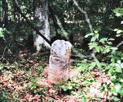
Submitted by: Annie Jones <AJones4151@aol.com>
Location just off
the Albritton Road in the oil field area. Take 84 East turn left onto
the Allbritton Road go until you see Pendarvis Rd. on left check your
milage from Pendarvis Rd. to road to grave is .9 of a mile turn left
onto road. Road goes to a oil well site grave is on right.
In
Memory Of
Maud May Daughter Of
Mr.& Mrs. F. V. Floyd
Born:
August 2, 1896
Died: July 1, 1906
Investigation by the
submitter has revealed the little girl was struck by lightening while
playing outside. This was the property where the family lived at the
time. Her father was Francis Victor Floyd and he and his wife are buried
at Beulah Cemetery in LaSalle Parish.
5 miles east on Hwy 126 then south on Delaney Road approx.. 2
miles to cemetery sign. 1/4 mile in woods.Host: Jimmie R. Newsom
Ford
Family Cemetery Photo
1, Photo 2
Ford,
Elizabeth A.
12/01/1832 - 10/19/1884
W/ O J. A. Ford
Ford, Riley
09/30/1885 - 01/06/1892
Son of J. A. & O. T. Ford
Ford, J. A.
11/07/1844 - 08/20/1922
Hatten, Infant of P. R. & M. E. Hatten
12/10/1906 - 12/11/1906
King,
Nancy Thornton
01/08/1860 - 06/29/1920
Submitter: Annette Carpenter Womack
Copied June 1978 by
Annette (Carpenter) Womack. Located 3 miles east of Sikes off parish
road
Submitter: Jimmy, Jr. & Kathy L. Kelly
Read on
December 13, 1997
There is a small metal sign showing where to
turn into the woods. Follow the tire tracks through the woods, around
trees, mud holes, etc. about 2/5 of a mile. The graves are inclosed in a
new hurricane fence, but badly overgrown with weeds--and snakes!!!
Elizabeth J. THORNTON: Aug 8, 1819 - May 10, 1867, Sacred to the
Memory of A loving wife. A mother dear. A Faithful friend is sleeping
here.
William Hatten: Jan 1, 1800 - Mar 7, 1860
Nancy J. Hatten: July 1, 1854 - Feb 6, 1858 daughter of W. & A. Hatten
William L. Hatten: Apr 4, 1866 - Dec 31, 1866 son of W. L. & A. Hatten, aged: 8 months and 2 days [very badly broken]
Lott, Patsy: No Dates, First wife of Wm. Hatten, Choctaw Indian Princess
Parker, Anna: May 4, 1832 - Aug. 25, 1901
6400 La. Hwy. 501, Calvin area
Submitter: Greggory E. Davies
Added notes by: B. Jo Branch
Date: 1 May 2008
From the
intersection of U. S. 167 N. and La. Hwy. 501 travel La. Hwy. 501 north
approximately 7 miles. Turn left onto U.S. Forest Service Rd. W520 which
is a white rock road. Travel approximately 75 yards to a white rock
trail on right. Follow this trail approximately 75 yards to cemetery.
Sheriff’s crime scene tape has been placed marking the trail.
Coordinates at trail: N31*57.026 - W092*45.552
Coordinates at
cemetery: N31*57.026 - W092*45.608
Arthur Jackson
1875-1951
NOTE: At the end of the trail, almost straight ahead by about 10 feet.
David Hobdy
d. 8-13-1903 age 56 years
Janne Ann McDade
1-17-1866 - 3-8-1900
NOTE: The above two gravesites are approximately
5 feet to the right of the Jackson grave site and 3 feet inward.
Elizabeth wife of J. W. Hobdy
1-28-1872 6-28-1912
Doubleheadstone: HOBDY
James W. Hobdy
1886-1944
Bertha
Thomas
1890-1928
NOTE: The above 3 gravesites are about 10
feet to the right of the Hobdy-McDade gravesites. Elizabeth was
apparently the first wife of J. W. and has a single grave marker. J. W.
and Bertha Hobdy have a double headstone just to the right of
Elizabeth's.
Submitted by William "Bill" R. Holly Jr., 500 Holly-Moore Drive,
Pineville, LA
Holmes Cemetery was read by Bill & Polly Holly on
March 30, 1998. This cemetery is on Holmes Cemetery Road. From U.S. 84
West of Tullos, LA, go North on Couch Road, turn left onto Holmes
Cemetery Road.
ALLEN, Mary J., b Feb 7, 1830, d Oct 26, 1862, w/o
H.W. Holmes
HOLMES, William H., b Dec 15, 1832, d Dec 25, 1858
SKINER, L.F.M.,
b Jan 4, 1884, d Nov 3, 1910
STRINGER, Daniel,
b No Date, d No Date, Co. B, 6 LA CAV, CSA
STRINGER, Mrs. Mary, b
1839, d 1896
Submitted by: Karen Collins Garrett, Winnfield, LA
Read 11 July
1999 by Karen Garrett
Location of Hurley Cemetery, by James C. Martin
of Calvin LA
Point of beginning: Intersection of LA Hwy 156 and La
Hwy 501 in Calvin, La. Travel North on La Hwy 501 seven and eight-tenths
(7.8) miles, to intersection of Yankee Springs Road and LaHwy 501. Turn
left onto Yankee Springs Road. Travel two and one-half (2.5) miles to
Yankee Springs Church. Travel eight-tenths (0.8) miles. Turn right on
Hurley Cemetery Road, identified by a sign "W024T". Travel one-tenth
(0.1) of a mile to sign identified "W024S". Travel two-tenths(0.2) miles
to Hurley Cemetery. It is located on left side of the Forest Service
Road. The Hurley Cemetery is located three-tenths (0.3) miles (North)
from Yankee Springs Road.
The cemetery is fairly large, well
kept and fenced, but only these few headstones remain.
Left side of
cemetery ......
William Jasper NELSON
B. 30 July 1876
D. 29
Aug 1914
Angie A. Martin HAMMETT
B. 1878
D. 1910
Oscar, son of
A.L. & Cornelia MARTIN
B. 17 Dec 1886
D. 7 Nov
1906
Cornelia & Emma
B. 12 Sep 1905 - B. 12 Sep 1905
D. 21
Nov 1905 - D. 16 Sep 1905
[double headstone, no surname given]
C.
H. E. H. [footstones]
NOTE: Briley's Cemetery Directory shows
these with the surname "Hurley". Also shows "dau. Geo. & Emma". Stone
was broken with apparently a section showing this info missing.
Right side of cemetery:
Concrete marker - no data
Appear to be
more graves (sunken areas) with no markers.
NOTE: Jesse & Mattie Garrett are buried here according to family accounts but no markers were found.
Submitted by: Lewis F. "Frank" Martin, PO Box 1871, Jena, LA 71342
Prepared for submission by: Peggy Beaubouef <pbeaubou@iamerica.net>
Old Warner Home Site - W. Winnfield at City Limits
Read 4 July 1992
WARNER, Jeremiah D., Co. G 28th La. Inf. CSA, NO DATES
Submitted by: Lewis F. "Frank" Martin, PO Box 1871, Jena, LA 71342
Prepared for submission by: Peggy Beaubouef <pbeaubou@iamerica.net>
Photos taken May, 2000 Submitted by Linda Lucky January, 2001
Price Salt Licks (Ward 10) - Read October 1991
LUCKY, John C.
CSA
5 Mar 1838 - 5 Oct 1861
LUCKY, Martha
Collins
4 Jun 1809 - 1 Jul 1847
LUCKY, William
15 Sep 1803 - 31 Jan 1872
MARTIN, E.C.
11 Apr 1827 - 27 Apr
1877
MARTIN,
James T.
1 Nov 1820 - 21 Nov 1861
MARTIN, M. E.
14 Feb 1862 - 2 Oct 1865
Child of Emily C. & James T. Martin
Infant
Unreadable
The following are unreadable. If you know whom they belong to, please
send it to the Parish Coordinator.
Photos:
#01,
#04
Submitted by: Brenda Reed
LOCATION: Off Hwy 167 about 2 miles in
the woods across highway from Williamette Sawmill between Dodson and
Wyatt.
Submitter's Note: I found out that Paul Stuart Quattlebaum
was born in Mississippi and was the son of Wilks Quattlebaum. My husband
said that he could take pictures of the graves if anyone needs them.
Andrew M.
Quattlebaum
Sept. 13, 1872
May 23, 1928
Wilks B.
Quattlebaum
Pvt. U.S. Army
Louisiana
Dec. 26, 1930 (only
date)
Paul Stuart
Quattlebaum
Dec. 2, 1846
May 6. 1935
Oakley Metcalf
Lufkin, Texas
(no dates - funeral home marker)
Infant
daughter of C. B. and Ida Quattlebaum
Oct. 7, 1921
Infant
son of C. B. & Ida Quattlebaum
17 Aug 1935 - 20 Aug 1935
Submitted by: Richard & Christa Medaries
Located in the woods,
about 100 yards east of Brewer Rd, and about 3/10 mile south of Jake
Creel Rd.
Photos by Greggory Davies & George W. Garner
Greggory E. Davies:
From Joyce, LA travel La. Hwy. 34
east to intersection of La. Hwy. 1236. Go right, across from
intersection of La. Hwy. 1236 and La. Hwy. 34 onto Jake Creel Rd. Travel
approximately 1.4 miles to Brewer Rd. Go right on Brewer Rd. and travel
approximately 2/10 of a mile to an old logging trail to left. Follow
this trail approximately 100 yards and cemetery is fenced, hard to see.
"As the crow flies" the cemetery is probably 50 to 75 yards off Brewer
Rd.
Coordinates at Brewer Rd. and trail: N32*02.476, W092*33.853
Coordinates at grave: N32*02.406, W092*33.766
Photo of
both markers together,
photo 2
R. A. Sanders, Dec 18 1856 - Mar 22 1932 AT REST
Sallia A.,
wife of R. A. Sanders, Nov 26 1873 - Mar 30 1917 AT REST
submitted by: Gregg Davies
photo taken and contributed by: Link Martin
Location: Ward 10, near the Salt Works
Slaughter,
Henry Hardwick
1826 - 1862 ?
Smith Grave Yard /Amandy Smith
Roy Johnson (the "camera man")
Jimmie Newson and
Mr. Bob Parker, who was their special "guide-for-the-day" found and
copied this cemetery. Copied: 07/29/1999
Photos taken July 29, 1999
by Roy L. Johnson
Location: [T12N,R1W,S11] HWY 499 to Sikes,
turn on Pinewood Road, Cross Doe Hollow, next Haul road to left.
Photos: #838,
#839
Notice in
the photos that posts were used for markers.
Smith, James A.
PVT Rogers Co. ALA.-Militia Indian War
December 24, 1889
Wade, Josephine
Wife of P. I. Wade, Dau. of James A. Smith
B.04/14/1870 -
D.01/30/1893
Submitted by: Lewis F. "Frank" Martin, PO Box 1871, Jena, LA 71342
Prepared for submission by: Peggy Beaubouef <pbeaubou@iamerica.net>
Location: 2 miles NE of Sikes - Read 14 April 1992
EMMONS, Amanda
D., d/o W.J. & S.L.
11 Sep 1873 - 1876
EMMONS, W. J.
1
May 1849 - 17 Apr 1876
PARKER, Etta Olwa, d/o W.A. & S.J.
19
Aug 1899 - 10 Jun 1901
PARKER, William L., s/o W.A. & S.J.
15
Mar 1889 - 1 Mar 1901
SIKES, Sarah J., d/o W.A. & S.J. Parker,
w/o John F.W. Sikes
17 May 1882 - 31 Oct 1901
UNDERWOOD,
Ellen W., d/o G.P. & S.L.
2 Sep 1887 - 3 Oct 1887
UNDERWOOD,
Louisa Alasam
24 Dec 1913 - 22 Jan 1917
UNDERWOOD, Sarah
Louisa
14 Oct 1845 - 18 Jan 1924
Submitter: Gregg Davies
Date: April 22, 2008
Special thanks
to Mr. Jimmy Newsom of Sikes for locating this grave site.
From
Sikes, LA travel La. Hwy. 499 north approximately 1.8 miles to Woodyard
Rd. Turn left or west onto Woodyard Rd. and travel approximately 3/10 of
a mile to an unmarked trail on the left. A set of iron bed head/foot
board serves as a gate. Follow the trail behind this gate approximately
3/10 of a mile.
Coordinates at Woodyard Rd. and gate: N32*06.603
W092*29.400
Coordinates at grave: N32*06.530 W092*29.667
Marked graves:
Mrs. E. E. Underwood
February 11, 1841 - February
28, 1894
Joel B. Underwood
October 18, 1839 - June 13, 1891
Infant of J. B. and C. J.
B & D November 12, 1902
Coordinator: Vacant
State Coordinator:
Marsha Holley
If you have questions or problems with this site, email Marsha Holley, State Coordinator.